Precision Forecasting
The Power of Precision Forecasting:
How AcuRite Focused Sensor Based Forecasting Beats Your Local Weather Channel – Whitepaper by AcuRite in conjunction with research conducted by Professor Paul J. Roebber, PhD. Atmospheric Scientist.
1. Introduction
If you watch your local TV news, you’ve probably noticed that the weather forecast isn’t always right. True, you can count on today’s weather to come close…so you grab your umbrella if they say it’s going to rain or reach for your scarf if they warn of an afternoon cold front. More often than not, you’re glad you took their advice.
But then again, we can’t help but feel frustrated when the weatherman promises an 80% chance of sunshine but somehow your sunny day of golfing is unexpectedly cut short by a storm.
Weather forecasters base their predictions on an incredibly sophisticated international network of weather measurement instruments. These instruments produce data that is compiled and analyzed by weather experts around the globe. That data is then fed into complex prediction model equations developed over decades of weather observation.
Multi-billion dollar weather prediction services have been developed worldwide to forecast conditions for time ranges from a few minutes to 10 days into the future. There’s a good reason for this! Estimates show that 39% of the $10 trillion U.S. economy is weather-sensitive (Dutton 2002). It’s not just about money. Well-developed national forecast services have proven time and again their ability to save lives.
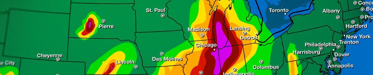
So with all the technology and expertise at their disposal, why does the local media still get it wrong sometimes? The answer is surprisingly simple. Local weather forecasts are based on a set of observations and computer models collected from reporting stations that may be hundreds of miles from where you live. Due to the large area covered by these forecast models, a 40% chance of rain means there is a 40% chance of rain at any given point across the entire region (see the National Weather Service explanation of “Probability of Precipitation”) .
In other words, your local meteorologist is forecasting for thousands of people (millions if you live in a metropolitan area) spread out over great distances. Quite frankly it’s practically impossible to get the weather forecast right for everyone in a given TV or radio market. When it comes down to it, an 80% chance of sunshine means that someone, somewhere usually gets rained on.
But what if you had a meteorologist in your own backyard whose weather report was tailored specifically for you? What if you could enjoy accurate forecasts specific to your exact location? Well, now you can!
AcuRite teamed up with noted atmospheric scientist Paul J. Roebber, Ph.D. to develop revolutionary, patented Precision Forecasting technology for AcuRite personal home weather stations.
But before we explain how it works, let’s examine how weather forecasting is traditionally accomplished.
Methods of Weather Prediction
Method #1: Global Weather Data Collection & Numerical Weather Prediction (How Your Local Weather Reports are Generated)
The primary method of weather prediction is to collect a wide range of weather observations both on the ground and in the atmosphere and then share the observations with a global network of weather-related scientists.
The data collection includes measurement of temperature, barometric pressure, and humidity. In addition, a variety of sophisticated data collection technologies are used, including satellite and radar.
Once the data is collected, atmospheric scientists use a technique referred to as “numerical weather prediction,” in which observations and measurements are entered into complex model equations. First, the model equations are used to analyze the current weather conditions. After that, the model equations are integrated forward to provide weather predictions.
Scientists then take this process a step further by incorporating “post-processing techniques.” These techniques include multiple linear regression, logistic regression, and artificial neural networks. Post-processing techniques enable scientists to refine and improve upon their basic model predictions (in other words, learn from their mistakes). Multiple linear regression, in particular, has become a standard technique for post-processing model data (e.g., Glahn and Lowry 1972). The idea behind post-processing techniques, in simplified terms, is to compare “what actually happened” to “what they thought would happen” and then attempt to make corrections to the prediction model.
This method is extremely effective at generating forecasts over large regions of the planet. But as mentioned earlier, this method may be less effective at generating highly-personalized, location-specific forecasts.
Method #2: Precision Forecasting: Focused Sensor Data Collection
A second method of weather prediction, called Precision Forecasting, enables highly personalized forecasting because it doesn’t require far-reaching networks of weather centers.
Instead, the Precision Forecasting method stemmed from the belief that over a period of time it’s possible to use the weather observations collected at the source (in your yard) to generate a localized short-term forecast.
How? Thanks to the known relationship between warm fronts and a set of key weather variables, it is possible to make reliable forecasts of temperature, cloud conditions and precipitation. These key weather variables include cloud thickness and height, temperature, humidity and barometric pressure.
Can Precision Forecasting weather predictions truly be made with reasonable accuracy using only basic surface measurements at only one site rather than in a network of sites? Atmospheric Scientist, University of Wisconsin - Milwaukee Professor and AcuRite Consultant Paul J. Roebber, PhD. has used the multiple linear regression and logistic regression frameworks mentioned earlier to help establish this method’s validity.
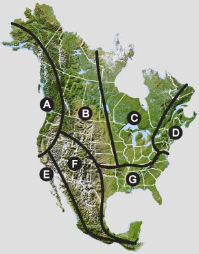
First, Dr. Roebber determined that the United States and surrounding countries feature 7 large, relatively uniform physiographic regions, and therefore they can be divided into 7 "Geo Zones" to capture basic, synoptic-scale
weather changes. The seven regions identified share common landscape characteristics and weather patterns (Fig. 1).
Within each of these seven sectors, a National Oceanic and Atmospheric Administration (NOAA) National Weather Service (NWS) station was selected. These stations are located in the following places: Northeast – LaGuardia (LGA),
Upper Midwest – Minneapolis (MSP), Great Plains – North Platte (LBF), Pacific Northwest – Seattle (SEA), Southern California – Los Angeles (LAX), Southwest – Phoenix (PHX), and Southeast – Atlanta (ATL).
Five years of hourly data were collected from each region’s designated National Weather Service station. Data included surface temperature, station pressure, and relative humidity. Once this data was collected, multiple linear
regression was utilized to produce an estimate of the low and high temperatures over a variety of time spans for each of the 7 regions. Then, multiple logistic regression was used to produce an estimate of the probability of
cloud cover and measurable precipitation for these same time frames.
In simplified terms, Professor Roebber looked at conditions for a specific time and place and engaged two commonly-used prediction methods to make short-term forecasts. After that, he audited those predictions against the actual
weather conditions that occurred to gauge how accurate the predictions were.
The results were impressive. Regardless of region, predicted temperatures were typically within three degrees Fahrenheit of the actual temperature. Cloud cover and precipitation predictions were varied from region to region, but
overall were surprisingly accurate.
“The results confirm that the Precision Forecasting method is capable of providing a reasonably accurate depiction of expected weather,” Roebber said. “In general, the [Precision Forecasting] method provides information that can
be useful for basic decision-making.”
Setup is Simple
AcuRite Precision Forecasting weather stations come preprogrammed with 7 different North American regional weather forecasting algorithms. To set up your weather station's Geo Zone, simply select the appropriate region based on the Geo Zone Map. The weather station will then apply the correct algorithm to generate your forecast.
PLUS Focused Sensor Data Collection: To account for fine-scale microclimatic details, Precision Forecasting combines your selected Geo Zone algorithm with the data collected by your outdoor temperature sensor or backyard weather station, to personalize your weather forecast for your exact location.
All AcuRite weather stations come with a wireless outdoor weather sensor. AcuRite weather sensors track changes in temperature, humidity, and barometric pressure.
Plan your day with confidence!™
So go ahead! Invite your friends over for a barbecue, ride your bike to the coffee shop or set a tee time armed with a reliable, personalized forecast generated right from your own backyard. It’s more than accurate, it’s AcuRite.™
More Information
Precision Forecasting: Your Personal Forecast, On Demand
References
Dutton, J. A., 2002: Opportunities and priorities in a new era for weather and climate services. Bull. Amer. Meteor. Soc, 83, 1303–1311.
Glahn, H.R., and D.A. Lowry, 1972: The use of Model Output Statistics (MOS) in objective weather forecasting. J. Appl. Meteor., 11, 1203-1211.


